It has a new photo viewer that is similar in function to Urban Digital's panorama viewer . I've been experimenting with it to create an educational resource. The background is that I work for a school of geography so identifying features from landscape photos is useful for teaching our students.

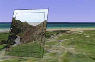
The screenshot shows a photo 'screen' I've placed in front of the location where the photo was taken, the photo is of a site we used in our mobile Google Earth project . If you open the file there are two photos you can access, one for you to interpret and one with the answer. The photos are taken with a normal 7 mega pixel camera, you don't have to use a gigapixel camera to make use of the functionality, you can zoom in and examine the image and see more detail than in the original view of the photo.
Some Observations:
- Using windows its still a bit flakey, I crashed Google Earth playing around with the viewer and folders yesterday.
- When viewing an image you move into a 'photo viewer', mode. I think a better signal that you are not in normal viewing mode is needed, IMHO it would work better if the rest of the screen were 'greyed' out when you are in this mode.
- This location isn't a wonderful example, the topography is quite complex but small in scale. The valley that can be seen in the photo isn't apparent behind the picture because the terrain data at this point is not accurate enough to render the valley properly.
No comments:
Post a Comment