Wednesday, February 24, 2010

Flat Earth II


A while back I discussed the advantages of a flat version of Google earth inspired by the movie clip above. You can do it via the Maps API for flash but that requires technical knowledge. A much easier way to do it is to put a world map in Google Earth as an overlay and add placemarks and loops (loops howto). I recently did this for a client, here's a stripped down version


The nice thing about it is that you could put all kinds of world maps in then narrate them with a Google Earth tour. So you could show a thematic map illustrating how much aid per country is being given to Haiti, then fly into Haiti on the Globe to see how the money was being spent.

Trick for the KML savvy: If you produced a tour that flew from a flat view like this out to country, you can edit the tour flyto so that it happens in a fraction of a second, users would then be unaware they'd flown out of a model map to get to Haiti.

Better than Screen Overlay: It makes for a better presentation than a screen overlay because you can add any sort of element above the ground overlay including loops, placemarks (as I've done here) and even other screen overlays.

Flat Map with Tours: One of the good things about this idea is that you can present a flat overview with 3D features like loops or Sketchup Models and in a tour, fly from the flat map out to the globe and zoom in on a particular country. So you could start with a thematic map showing how much individual countries were donating to Haiti then switch back out to the 'real' Google Earth and fly in on Haiti itself to see how the money was being spent.

Tip for the KML Savvy: You could even edit the flyto tag speed to be a fraction of a second, this would take the viewer from the flat map to a high view above the country without them even being aware that they've moved between transitions.

Thursday, February 18, 2010

Tuvalu Flooded in Google Earth


Tuvalu is a Pacific island famous for being vulnerable to global warming induced sea level rise. I've discovered in Google Earth, its already sunk a long way! A case of the model of the sea floor not being accurate enough in Google Earth. See more in this tour (needs GEarth v5+).

Other Sunken Islands: Previously I spotted the Scilly islands were underwater off the coast of Cornwall.

Friday, February 12, 2010

Global Warming, Snow and Ice tour


Lisa Ballagh of NSIDC wrote to point out their new 'Climate Change Tour of Cold Places', its a tour in Google Earth. She asked for feedback so I thought I would review it as a post. She also says she found my series of tour tutorials very useful, glad you liked them Lisa!

Overall Comments:
  • Good Work!: A lot of work has gone into this, overall I think its successful and informative.
  • Good Topic: Climate change of cold places is an excellent topic to tackle in a virtual globe because its very spatial (e.g. permafrost is more common closer to the poles). Also, people don't generally look at the poles on a globe so its good to get flown there to consider them.
  • Convert to YouTube: Given the amount of effort involved, I would definitely convert the tour into a YouTube clip as well. See discussion on this point.
  • Too Long: I think if NSIDC tracked how users access the tour they would find that its too long and that users were stopping part way through. 3 minutes is my guess as a good length of tour in this sort of instance, a solution is to split off the tour into separate parts as was done in the Colombia bridges tour.
  • Other Great NSIDC Content: On the same page as the tour page as the tour but lower down, the "Sea Ice: Daily Concentration and Extent" KMZ project is still one of my favourite GEarth projects.
Numbers in the next two sections refer to time in the GEarth tour itself

Pros:

  • Auto Play YouTube Clips: The use of youtube clips in the tour that automatically play (e.g. 8.47) is inspired. I'll be stealing that code and using that trick myself!
  • Good Start and End: Use of start screens, end screens, advice to turn audio on and which layers to select is well thought out.
  • Good Images: Good images have been selected for use in the tour, especially the retreat of glaciers.
  • YouTube Clips add Human touch: I think the youtube clips themselves add the human touch to the tour, making the content more accessible.
Cons:
  • (6.33) Fix Photos in Position: At 6.33 an image of Muir glacier slides across the screen showing before and after of glacial retreat. It would be better to fly into the Muir glacier and find the position from where the photo was taken and then overlay the before and after images one by one so they mimic the GEarth view. This gives users a sense of where the glacier is making it more memorable.
  • (7.12) Flight too Fast: Flights from A to B should be looped to include a high altitude view. This helps viewers work out where they've come from and where they're going. They should also be less fast than this one - most users won't follow where they are going at this speed. However, having said that, other flight segments within the tour were timed correctly.
  • (4.41) Split Attention: At this time the audio is describing something about glaciers while the placemark label asks the question, "why is Greenland called Greenland?". Users will be distracted by this, it's best not to split their attention, one way around the problem is to make the placemark only appear on screen when the audio track asks the question.
  • (4.41) Placemark vs Polygon: In discussing Greenland it should be marked as a polygon across the whole country with a camera view showing the whole country rather than the placemark shown at low altitude. A popup will work just as well from a Polygon.
  • (10.13) Timeline Labels and Annotations: To give viewers a sense of the time of events you could add labels for the times of each image. The timeline labels just aren't big enough to follow clearly. You could add annotations to show the physical scale (Rhode island outline over the ice?) and also add a polygon annotation to show the original extent of the ice shelf. The polygon island annotation should persist throughout the animation as the shelf disintegrates.
To summarise, this is a good tour with some innovations I'll be copying in the future. Although there are some cons I think they're quite minor points and don't distract from the quality of the work overall.

Wednesday, February 3, 2010

HowTo: Photos in Pop Up Balloons

The Need: Recently I've been investigating GIS systems for schools. One of the functionalities that I was struck with in other systems (AEGIS and DigitalWorlds) is ease of linking photos with locations, this isn't easy in Google Earth. If you drag and drop a photo from Windows Explorer into Google Earth (V5+) it creates a Photo Overlay, a kind of virtual posterboard, at the camera view you are currently using. It isn't very usable IMHO because of its 'modes' also, being able to click a placemark and get a pop up balloon is much more useful educationally. Creating a photo in GEarth in a pop up involves writing a bit of html code which is too confusing for most users.

Upload to Panoramio: A solution is to upload photos to panaramio. This is pretty simple and straightforward but
  • Involves a time delay between upload and being able to view images (my recent uploads still haven't come through after 24 hours)
  • Requires that photos already on a computer are uploaded to panoramio to be viewed back on the same computer.
So I've created a tutorial using a spreadsheet to help create photos in pop ups:

HowTo:
1] Assemble photos in a single folder somewhere on your PC
2] Create placemarks that will be links to the photos


3] Open Windows Explorer to view the photos. Select the view to be of tiles either by use of the icon or by the View > Tiles menu. Both are shown below marked in solid red:
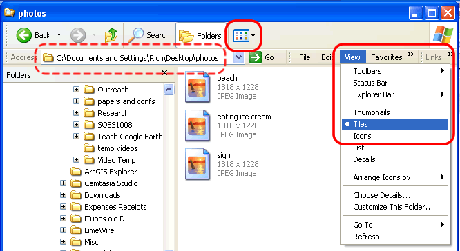


4] Open the photo creator spreadsheet. Select the address box (dotted circle above) and copy all the text. In the 'Location of Folder' box (cell C2) paste the location of your photos.


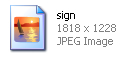
5] Now copy the name of the file into the 'Photo name' column. For my photo as it appears in windows explorer above, it would be 'sign'.

6] In the drop down list 'Photo type' choose the type of your photo. '.jpg' is the default, its written 'JPEG' in the screen shot above.

7] Put the original width and height into the relevant columns. From the above screenshot the height is written first and is '1818' and the width second '1228'.

8] Usually a digital photo produces a pop up that is too large so we have to reduce it's size. To do this, put the width of the photo you want in the pop up in 'GEarth Width'. The speadsheet scales the photo to the new size. 300 pixels is a good starting point.

If you want to come back and change the size as it appears in the pop up you alter just this number (leaving the other two columns alone), the spreadsheet will recalculate the text needed, so repeat step [9] but remove the old text in the description box then paste in the new.

9] Once you have entered all the data click on the cell 'Copy This' and copy it. Now go to the relevant placemark in Google Earth, rollover it with your mouse Right Click > Properties and paste the text into the big Description box. Click OK. Now when clicking the placemark again your photo should appear.

10] Repeat steps [5] to [9] for up to 10 other photos. Should you want to come back and change sizes later, all the information for earlier photos is still in the spreadsheet.

11] Create a folder in Google Earth. Click 'Temporary Places' in the Places column then Add > Folder. Drag your photo placemarks into the folder.

12] Now right click the new folder and click 'Save As'. Save the folder with a sensible file name somewhere as a .kmz file (should be automatically selected in the 'save as type' box at the bottom of the dialogue box).

By doing this Google Earth copies the photos from the original location and zips them up into one file, so you can send the file to someone else and the photos open up as they should. You can also remove the original photo folder from your computer and the placemarks will still work.

Troubleshooting: Check that:
  1. The location is exactly as it appears in windows explorer [4]
  2. The name is exactly the same as in windows explorer, check uppercase or lower case. [5]
  3. You did step [6] and that your image is a .jpg, .gif or .png file
  4. That you have entered relevant numbers in all the 3 image size columns [7 and 8]
  5. That you copied all the text from the string
  6. Failing all of the above, discard the spreadsheet and open it blank again from the link above and retry.