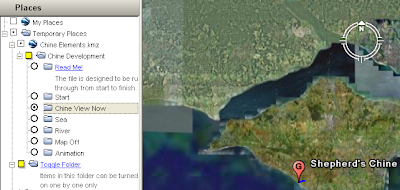
By Picture Frame I mean that you arrange a number of items that make up a logical view and put them in a folder. You could also think of a picture frame folder as a map. With a paper map layers cannot be turned on and off, this can be achieved with folders by deselecting the 'allow this folder to be expanded' tick box in properties.

This is a screen shot of a project where I did just that. I created the 'Chine Development' folder and selected the 'show contents as options' tick box in properties. I then created a number of folders each with a some elements (placemark, overlay) inside that made up a 'picture frame'. The radio buttons you can see alongside the sub folder icons tell you that only one of the sub folders can be selected at once and I made it so that sub folders cannot be expanded.
I've posted before about needing to convert the tour of this project to a video, however, the folder structure shown above works just fine to create picture frames. Maybe picture frames are a good way of presenting the best of your project? You could cherry pick your data, arrange the data elements into picture frames and publish a set of them as a data summary (rather than an introduction which you should have as well). The rest of your data could be published separately for the power users to explore.
No comments:
Post a Comment