The problem is that users with a low IT literacy skills may not realise regions are operating, they can click a layer in the places column and be annoyed that nothing appears because they are at too high an altitude to load the placemarks in. To my high IT literate readers this may seem a petty point surely they'll explore and find the placemarks popping up? No. They might not. They might click away and find the secret middle section to the magic roundabout theme tune*. In which case you've lost them.
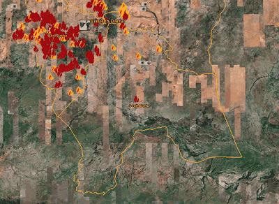
I have a solution. Below is a zoomed-in a view of the Dafur default layer** which uses regions, notice the red one out on its own center of the image.

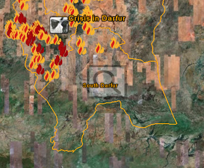
If you zoom out it will dissapear. But in its place a translucent magnifying glass placeholder tells you there is something worth zooming in to see in the square region it marks. Obviously this works best when there are multiple placemarks hidden under the magnifying glass placeholder.

The magnifying glass image overlay can be tagged with its own region so it appears at an altitude above the one where the placemarks appear. It should also be explained in an introduction otherwise users won't understand what it means which is as bad as it not being there in the first place.
*Non UK readers will struggle to understand the humour to this.
**Disclosure: I'm currently doing some consulting for USHMM on Google Earth.
4 comments:
Richard, now that KML 2.2 is on its way to being an official OGC standard (couple of weeks, right?) what's your guess as to other client tools starting to support regions, like as a practical way to tile pixels (since the WMS tiling/caching ideas are still a ways from adoption). Any thoughts, or have you heard any news?
Sounds sensible but I don't know enough technically to understand the problem.
rich
Another use for regions is to simplify polygon/polyline data which must be presented at full-quality when zoomed-in on GE, but can be simplified when zoomed out.
Examples are commercial-grade data such as LiDAR-derived contours and 7cm aerial photos, which will be exportable from Koordinates (I'm CEO of Koordinates - http://koordinates.com).
The magnifying glass idea is a good one. My primary concern with improving KML's to work better in GE is that other KML-supporting software makes them look messy.
Ed,
Using regions to change the resolution of data is a great idea. Thanks for the tip
Rich
Post a Comment