Showing posts with label Esri Story Maps. Show all posts

Monday, January 9, 2017

Three Geo-Animations for Atlas Tours (Google Earth Tours, Esri Story Maps)

Just less than a year ago I published a post about 3 types of Atlas tour (1).   I've been thinking about the topic over the last year as I've been writing papers so I thought I should develop that post with some more detail.  I discussed this in my recent Google Education talk.

Types:
Just as you can have different types of PowerPoint (fieldwork briefing, photo slide show, talk etc. etc.) you can have different types of Atlas Tour.  Esri Story Maps (ESM) have identified a number of different types which emphacise text narrative, I believe most Atlas Tours should be narrated using audio, so I'm not going to discuss those.  My sorting works on two axes:

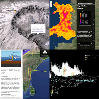
  • 3D or 2D:  ATs can be used to discuss both landscape (3D) or map views (2D).  
  • Realistic base map vs Symbolized:  showing realistic imagery works well when illustrating landscape but symbolising is endlessly useful in paring down a map to simlyfy it to the elements needed (e.g. temperature and wind but nothing else bottom right below)  
which produces 4 groups.  These are illustrated in an image grid below (2):


I give examples of the four groups in this videod section of my Google Education talk recently.

Geo-Animations
Within an Atlas Tour, you can have different types of animation that are highly suited to the format, I've identified 3 which I think are particularly useful and to illustrate them I've prepared a story board of an Atlas tour discussing the famous Snow cholera map:

1] Map Sequence:  using annotations or revealing layers (build animation) of a map one by one in order to explain a complex map.  The sequence above illustrates the build animation with street names added and then the pump.  It becomes much more important on complex maps.

Click to expand.  The audio narrative script is found under each image.


2] Time Animation:  Showing a sequence of maps to show change due to time.  This is well discussed in the cartographic literature.  Note that I've invented data, the spread was actually not recorded.
Click to expand


Avatar animation:  flying down from a symbolised map view into a 'human' view.  This is an original idea of mine and IMHO is very powerful, you can illustrate spatial relationships and then follow up with showing what they look like in real life.  In this case, on the street.

Click to expand


these aren't the only animations you can use and you can certainly usefully link out to static imagery and non-map video from within a Atlas Tour.  However, they are all very spatial and so worth highlighting above other formats in an Atlas Tour.


1] at the time I called them Google Earth Tours but to include people interested in using Esri Story Maps I now use Atlas tours as an encompassing term.

Thursday, October 20, 2016

New Paper: How to make an Excellent Google Earth tour

We (myself and Artemis Skarlatidou) have just submitted a paper to a cartographic journal about a successful experiment we did on users' understanding of Google Earth Tours.  The work produced two rules of thumb to consider when making Google Earth tours so I thought I'd blog about it.  Note that the title of this post isn't how to make a 'cool' Google Earth tour that grabs users' attention, this is about how to use them as an effective communication tool.

Why should I care about Google Earth tours?
Before we get to the two best practices its useful to think about the media we're discussing.  Is it worth using?  My answer to that is that Google Earth tours are common on the web and the wider generic group of Google Earth like animations (Atlas tours) are everywhere!  e.g.:
- TV (e.g. weather forecasts)
- The web (e.g. National Geographic)
- Mobile satnav apps

As an example of Atlas tours in satnav apps, both Google Maps and Apple Maps in driving directions mode will zoom into tricky road junctions when you approach them but then zoom out when you are on a straight road section to show you the wider view.

So you should consider creating a Google Earth tour (or Atlas tour if you prefer) as a way to tell your spatial story.

Best practice 1: use high paths
If you are producing a tour with two or more low points, you get to choose how the camera moves between the two low views.  Users' mental map of the study area will be better when your tour following a 'Rocket' path(1) where there is a mid point where you can see the start and end of your tour. This video explains the point and tells you how to achieve it technically in Google Earth:


Best practice 2: use of speed
We haven't explicitly proved it but an animation speed of 1 second for any camera motion is a good rule of thumb(2).  If the tour is more visually complex, you may want to slow the speed down.  Reasons to take more time:
- You are flying through a complex 3D cityscape
- There are lots of elements on screen (points, lines, areas) that you want users to understand

As an example, these are some of the experimental Google Earth tours; only the 'low, fast' condition really troubled the users in the experiment.


Conclusion:
Atlas tours are very common as they are an effective media to communicate a spatial story or data.  Google Earth is one of a suite of software that can be used to produce Atlas tours, I think the principles described here will apply whatever software is used.

I read all the studies I could find in 2011 and produced an earlier paper which discussed these and 17 other best practices for producing Google Earth tours.  This is the shorter blog version of the paper.


Notes
1] In the paper, this is called the high path.  Less memorable but more professional sounding.

2] our experiment ran at speeds slower than this and user's had little problem building up a mental map of the study area.

Friday, August 26, 2016

Students creating Atlas Tours (aka Story Map, Google Earth Tour)


screenshots from student produced ATs I found on the web
Screenshots from student produced ATs I've found on the web
What is an Atlas Tour? So I’ve been writing some papers over the summer about ‘Atlas Tours’ (ATs) by which I mean a series of maps that tell a narrative.  An example well known in the UK residents is the BBC TV weather forecast


which is made up of animated time maps, camera motions through virtual space and a narrative delivered by a presenter.   In UK outreach events I used to run teaching geography, this was the ‘map’ that people said they looked at most often.

ATs encourage users to watch: A great example of how useful ATs are is from National Geographic who produced this site about tracking the illegal trade in ivory across Africa .  The web logs of this resource show that atlas tours encourage people to engage more with content than other non-narrative, interactive maps (Kaitlin Yarnall Presentation at 18.40 minutes).  

Easy enough for students to do:  The cool thing is that the technology (and I'm thinking Esri Story Maps and Google Earth Tour Builder here) has made it easier for students and other non-specialists to produce ATs almost as sophisticated as the Ivory trade example.  As a result a number of assignments have been set asking students to produce ATs, a good example is the PSU and Esri MOOC which asked students to produce a map based story as a final project, many chose to produce ATs via Esri Story Maps (Anthony Robinson and Colleagues paper (2015) )

Other Examples of students’ ATs on the web include: 
One of the papers promotes ATs as a good assignment to set students, watch this space for more!

Monday, February 29, 2016

Three Types of Google Earth Tour

I happen to have been thinking about the different types of Google Earth tour recently.  I've come up with three main types:

3D Flyover:
This type uses just camera motion and is through an area of significant topography (think mountain range) or other 3D structure (think buildings or Geology).  Its immersive in the sense that it is close to flying through the actual landscape presented.  Here's an example:

http://www.nps.gov/grca/learn/photosmultimedia/fly-through.htm

I think this type is a bit old, people were very excited by them when they were first possible but now we've all grown used to Google Earth they don't impress that much anymore.

Map Tour:
In this type the viewer is flown from location to location with other media being used e.g. photos or overlays on the topography.  It may use other map animations such as time animations but these are more minor.  It doesn't really try to be immersive, the power of the camera movement is to explain the relative locations of things or to illustrate maps over two or more scales.  A couple of examples:


Time tour:
This final type is more an animated map than a tour, it is mainly time animation with camera motion being a less significant animation type.  Like the map tour, it doesn't aim for an immersive experience but instead uses Google Earth as a base map on which to present thematic data over time.  A good example is this sea ice animation from NSIDC: