Wednesday, November 26, 2008

Audio Narration vs Text

Over at Digital Geography Noel has been experimenting with flash based audio with the help of Vocaroo.com, it works well. I discussed audio in Google Earth a year ago but using evoca which was free then but now only has a free 30 day trial, so my audio links in the Nile tour are now broken.


Screenshot of original audio tour experiment.

A partly redone example using Vocaroo:

A couple of thoughts occurred to me:

Audio in Teaching Animations: Mayer and Moreno experimented using animations for teaching. They found that students performed better on tests when they had used animations (such as how a piston works in a car engine) with audio narration rather than with text narration. I strongly suspect that in a Google Earth tour an audio narration will similarly perform better than a text narration for users so this is something we should be doing more of.

Web Services may Change: My experiments with Evoca were free, it would be fine for a student project but if you want something that will last into the future you can't rely on a web service, they may start charging as with evoca. I've experimented this morning with trying to add narration to the web without a web service and the results aren't good. At the moment its still fiddly and requiring techie skill: I used the free and open source Audacity for recording and this tutorial for adding a flash player with sound files. If someone knows an easier way to get audio on the web in little flash applets without using a web service I'm all ears.

Friday, November 21, 2008

BookWeb vs GeoWeb

The web as we know it is based on a book analogy. It started out as little more than text with hyper links. Growing more sophisticated, the addition of multimedia and databases still hasn't altered the central book analogy: a web site is still made up of web pages whatever its content.

IMHO the GeoWeb represents the first radical divergence from this form. In the early days of the web maps were static, but now they're dynamic and involve 3D models, videos and time animations. Such a media is now way beyond what can be called a 'map', but it is map based because the navigation is not structured like a book, its primarily a spatial arrangement. Which goes someway to explain why I talk about Google Earth projects on this blog and don't refer to this or that .kmz file. To me its the difference between between a website and a .html file.

A lot of the terms we use on the web are spatial or have spatial roots e.g.: website, navigation, site map and cyberspace. In fact spatial thinking and location are such a central human approachs to thinking that I wonder if the GeoWeb has the power to overtake the BookWeb. It may happen, it may not but if it does I don't think any of us has the faintest idea what it will actually be like.

Everyone have a good weekend.

Wednesday, November 19, 2008

Case Study: Time Based Data Practical in Google Earth

I thought today I'd describe my efforts with a recent piece of work I've been working on: Enhancing some excellent data from the NASA visualization lab to be put in a practical for students on an introductory course in Oceanography at Southampton University.


Plankton Bloom around Galapagos Islands from practical. Red indicates high density.

Data Set and Central Challenge: The data I was enhancing was changes in sea surface temperature and also plankton density with time (the two have an important relationship that I won't go into here) during an El Nino event. The central problem of the practical was that dealing with multiple sets of time data is tricky and I planned to have the (400!) students attempt the practical unsupervised so there was no one on hand to help them out if they got stuck.

Approach 1 Issues: My initial approach was to produce a video tutorial to cover the aspects of timeline control they would need and then direct them to manipulate a single Google Earth file. The tutorial here is a low bandwidth version of that video tutorial. However, whilst testing the practical before release on two likely users I discovered they were still struggling with 2 main problems:
  1. Dry Content: The tutorial explained a number of pretty dry concepts (e.g. dragging timeline handles to download images) without getting the students to immediately apply the concepts, as a result they didn't really concentrate on it.
  2. Tricky Controls: Manipulating the layers was still tricky even after watching the video tutorial, it requires you to tick the right boxes, make sure the right layers are selected and also understand how to manipulate the timeline.
Getting the students to grapple with problem [2] is a good thing, learning to manipulate web map systems is a skill that can then be transferred to other applications. However, problem [2] was bigger than expected so it was unfair to ask the students to deal with it IMHO, especially because the practical was unsupervised.

Approach 2: Instead of 1 google earth file I gave the students 3 separate ones to open at different points in the practical with the layers arranged correctly within each file. This meant they didn't have to work out how to manipulate the data as I had set the folder structure up in advance (as discussed last week). I still had to teach them about some aspects of the timeline but I managed to do this using static diagrams within a set of written instructions. These two approaches allowed me to ditch the video tutorial completely, I failed to teach them many skills about layer control but IMHO this was worth the sacrifice.

Lessons I draw:
  • MOST IMPORTANT - Testing: This sort of thing only appears when you do some kind of testing of your content before release. You don't have to kill yourself with this, hallway testing is sufficient.
  • Splitting Content: Splitting the content up into different Google Earth files was a useful strategy in this case. Its a useful strategy elsewhere (#7 of my review points).
  • Keep it Simple Stupid: In the end, the simpler solution is often the best, I'm often pleased with the clever things I've done but in this case when it proved ineffective, I was prepared to ditch it.

Wednesday, November 12, 2008

Controlling First View of your project

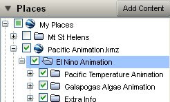
Good Practice Point: When producing a Google Earth project for the public it is important to decide what data is showing when the user first opens the file. For example, you can prepare a view of the places column where some sort of 'read me' placemark introduces your work with an overview map visible. All other data is hidden which this helps to avoid overwhelming the user with too much information when they open your project.

HowTo: To do this select which files you want visible by ticking/unticking them and choose whether to open or close folders by expanding them (the '+' or '-' icon to the left of the tick box). If you arrange the elements in one parent folder you can right click > 'save as' the current file structure is recorded so it reopens in exactly the same way on a user's machine.


Possible Bug?: There seems to be a bug in GE
4.3.7284 which means that you must remember not to save the parent folder ('El Nino Animation' in the image) but save the actual .kmz file ('Pacific Animation.kmz' in the image) entry in the Places column. If you save the former it defaults all folders to be closed.

I talk more about introductions here

Thursday, November 6, 2008

GIS in UK teaching

Teachers in the UK are suddenly being faced with curriculums(ae?) that suggest use of GIS in teaching. Here is the copy of a post (on a ning site) I've just written discussing the subject:

I've read this thread with interest. I'm the outreach officer for the School of Geography, University of Southampton and my research area is IT in geography education. Part of my research role is to watch how technology and use of it is developing, my opinion is that you don't need GIS, you only need Google Maps/Earth.

As outreach officer I've been producing school lesson plans based on Google Earth, so far one on flooding in the Brahmaputra, one on volcanic hazards on Hawaii:
http://bit.ly/1mdcFS

I've also put together a web based manual on using Google Earth:
http://www2.geog.soton.ac.uk/users/TrevesR/ge_tut/

Back to the discussion. You may ask: Isn't Google Earth/Maps GIS? Strictly, yes, but its probably better described as part of the geo-web (along with packages like ESRI explorer, MaqQuest and users of the new Google Earth API such as earthswoop.com). A simple description that mostly works is that the geo-web is heavily based on connection to the web (surprise, surprise) and is about geo-visualisation rather than about analysis of spatial data which is what GIS is about. Fly your students from space down to view Sellafield in Google Earth and that's visualisation, calculate what houses are within 50 miles of the plant using buffer zones and housing data, that's analysis.

I have read a couple of UK school curriculums(ae?) and when they suggest GIS they are talking about geo-visualisation not analysis. I've also checked that out with the education department at RGS who know far more about schools than I do and they agree with me. Not needing 'GIS proper' is good because it means you can use Google Earth/Maps which is free, comes with free data worldwide and is much simpler than any GIS to operate.

Points made in your messages:
software going obselete: One of the advantages of Google Earth and Maps is that the file types they use (.kml and .kmz) are becoming the standard way to package up geographical data. This means that if you create a lesson plan using kml files and (not that I think it will) Google Earth dissappears, you will be able to read them into a similar program. That protects you from this problem. I could expand this point if anyone's interested but I'm guessing most of you aren't.

lack of PC access: Not a lot can be done about this, student access to computers is obviously the best option in a teaching situation. However, a lesson with a single teacher controlled PC can be a good second best and my Brahmaputra lesson plan discusses this.

Size of software being too big for your system: I would guess that Google Earth would be less demanding to operate than many GIS systems, however, it does require a good internet connection and graphic card capabilities to work well may be a problem with some set ups. However, a lot of good work can still be done using My Maps in Google Maps and that will run on much less powerful machines with less good internet connections.

The example of Earthquake maps linked to spreadsheet data: Plotting point data can be achieved using Google spreadsheets and Google Earth, see:
http://earth.google.com/outreach/tutorial_mapper.html
I would hesitate to recommend you use an online spreadsheet in a lesson as it can operate very slowly. However, you could get students to put data into an offline (eg. XL) spreadsheet, email the data to you and you could collate the data and operate the online spreadsheet. I've also produced my own purely XL based spreadsheet for producing point data, its not any use in this instance but proves the more general point: Most things you would want to do in your lessons that involve computer mapping you can do with Google Earth/Maps for free.

Wednesday, November 5, 2008

Lesson Plan: Hawaii Volcano Hazard


Back in June I published a detailed lesson plan on flooding in the Brahmaputra.


Today I have published a second plan on the volcanic hazards on Hawaii. Not only does it teach geographic principles about lava hazards and topography it also explains and uses the 'runaround' technique I've developed which I mentioned here with respect to second life.

Runaround Idea: The basic idea is to put a grid on the floor, then project a map on a screen. Students are asked geographical questions and move to a position to answer the question. Its a development of a warm up game used by Geese Theatre Company.

Advantages:
  • Multiple students can respond to a question (c.w. a traditional lesson situation where only one student can respond to a teacher question at a time)
  • Response is a position rather than an area: For example, if I asked students to locate London on a world map using runaround they could answer quickly with a point. If I asked them without it they would have to answer 'In England' or the clumsy 'far southeast corner of England close to the east coast but a fair way in from the south coast'.
  • Students seem more engaged and interested than in a traditional lesson which I put down to them having to stand up and move around constantly. This is in line with the (unproven) theory of Kinesthetic Learning.
  • They find it fun!
Volcanic Hazards: The lesson itself is based on the volcanoes of Hawaii which I know about from having volunteered at the Hawaiian Volcanoes Observatory 5 years ago. The lesson has been tested a number of times but isn't as polished as my first lesson plan, I made the decision that it was better to produce a number of lessons rather than fewer ones that are better polished. Noel has published a lesson plan on a similar topic for Moneserrat.

And for any Brit who's suddenly nostalgic for 70s TV here's a runaround clip: